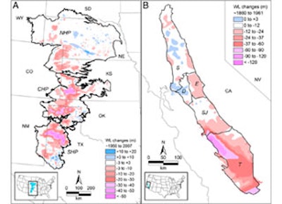

(Newswise) — Groundwater depletion has been most severe in the purple areas indicated on these maps of (A) the High Plains and (B) California's Central Valley.
These heavily affected areas are concentrated in parts of the Texas Panhandle, western Kansas, and the Tulare Basin in California's Central Valley. Changes in groundwater levels in (A) are adapted from a 2009 report by the U.S. Geological Survey and in (B) from a 1989 report by the USGS.
The nation's food supply may be vulnerable to rapid groundwater depletion from irrigated agriculture, according to a new study in the journal Proceedings of the National Academy of Sciences. The study paints the highest resolution picture yet of how groundwater depletion varies across space and time in California's Central Valley and the High Plains of the central U.S.